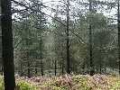
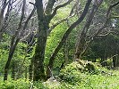
Blackdown Woods
surrounding
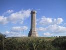
Hardy's Monument
A Site of Special
scientific interest. Back in geological time a river system deposited gravels
onto the underlying chalk and plant communities have developed which reflect
the more acidic soils.
Sand and gravel used to be quarried from the heath
and the old pits are still to be seen. The more conical depressions are called
"swallow holes" which are formed when acidic water dissolves away the chalk
rock beneath the surface layer of gravels.
Blackdown lies on the
South Dorset Ridgeway, a chlak ridge stretching for 12 miles. It
provided a natural pathway for early man and today the ridgeway is still dotted
with the remainrs of the many "barrows" or burial mounds built during the
Bronze Age (2000-600BC).


Bluebells and sheep


Click on the thumbnails for bigger pictures and descriptions.